THE CHALLENGE
Featured Post
The Banff Three Peak Challenge is a grueling, 70km route up the main peaks surrounding the town of Banff, Alberta. Starting and ending at The North Face store, this ultramarathon sees the challenger to the summits of Cascade, Rundle, and Sulphur mountains. Many have climbed all three peaks in one day, but very few have ever attempted to run between them (I have only heard of three). Besides the massive amount of elevation gain, the main obstacles of the route are heat, exposure, wildlife, your body and mind, and scores of tourists. It is a great feat to summit one of these mountains in a day, but to run (and power hike) all three is something out of the ordinary. Below are stats and descriptions for each mountain, as well a route map. Currently, I plan on making an attempt on July 11, 2015!!
01 - Cascade Mountain
Summit Elevation - 2,998 m (9,836 ft.)
Elevation Gain - 1,535 m (5,036 ft.)
Distance - 18 km round trip
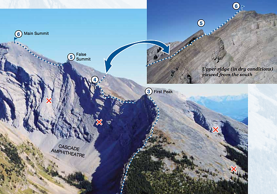
Cascade Mountain is the highest of the three peaks, as well as the furthest distance travelled. Starting by running up the Norquay ski area, the trail traverses along the bottom of the ski area before descending through the forest to Forty Mile Creek. The trail now climbs steadily up switchbacks to Cascade Amphitheatre. This is where the trail ends, and the scramble to the summit begins. The route climbs over a large bolder field and over the first peak. From here you must skirt around the front side of a false summit, along a narrow exposed ridge, and then up the final ridge to the summit. For most hikers this is an 8-10 hour day!
02 - Mount Rundle
Summit Elevation - 2,949 m (9,675 ft.)
Elevation Gain - 1,486 m (4,875 ft.)
Distance - 15 km round trip
Although Rundle is not as high as Cascade, it can be considered a harder climb. The route starts by the Banff Springs golf course and Bow Falls. The trail traverses the side of the mountain, climbing steadily through the forest. There are many sections where you can see kilometers down the trail as it is very straight (but not flat). A section of switchbacks climbs through a steep rock band, and continues to a large gully. From here the trail climbs straight up the mountain where you emerge from the trees and into the alpine zone. The scramble ensues, and crosses a ridge know as the 'Dragon's Back'. With a drop off on either side of over 100', the ridge can be daunting to some, and becomes only a few feet across at the narrowest point. From here it is a long slog up scree (likend to going up the down escalator) to the summit. For most hikers this is an 8-10 hour day!
03 - Sulphur Mountain
Summit Elevation (Sanson's Peak) - 2,256 m (7,402 ft.)
Elevation Gain - 793 m (2,601 ft.)
Distance - 12 km round trip
Sulphur is the most tame of the three mountains. A nice, wide trail zig zags up the mountain, with short sections crossing underneath the gondola. Once you reach the top gondola station, a short boardwalk leads to Sanson's Peak and Cosmic Ray Station.
Route Map
Total Distance - 70 km (Includes running through town)
Total Elevation Gain - 3,814 m (12,514 ft.)
Fastest Known Time - 12:55:00 (Ian MacNairn)


Photos Courtesy of Parks Canada


Photo Courtesy of Parks Canada


